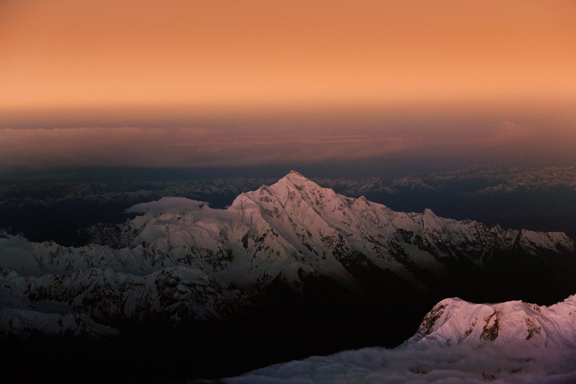
Eric Shipton called the Hunza Valley “The ultimate manifestation of mountain grandeur”. Rakaposhi is valley’s most famous peak. The huge massif dominates the skyline for vast stretches of the Karakoram highway, first seen North of Aliabad yet still visible as far south as Gilgit. The peak is located in the Rakaposhi-Haramosh range which forms the south-western corner of the Karakoram and is part of the Lesser Karakoram. The mountain is extremely broad measuring almost 20km from East to West. It is the only peak on Earth that drops directly, uninterrupted, for almost 6000m from the summit to the base. Besides the highest peak of the Rakaposhi massif is Rakaposhi East (7010m). The peak also holds significant value to Geologists as it is the prow of the Eurasian land mass with Nanga Parbat representing the prow of the Indian land mass.
In local Burushaski language Rakaposhi means “Shining Wall” (not to be confused with Gasherbrum I which also means “Shining Wall” in the local Balti language). The peak is also known as Rakapushi, Pk 27/42L and Dumani (Mother of Mist).
Due to the mountain’s prominent position in the center of the Hunza valley many have considered climbing the peak but relatively few have attempted the summit. For this reason, the mountains maintain a certain enigma for many who visit the area. The mountain is not easy to climb from in any direction. Western routes are very long, northern routes are very high and technically difficult, and southern and eastern routes are plain dangerous due to extreme avalanche risk.
After six failed expeditions the peak was first climbed by a “British-Pakistani forces Himalayan Expedition” in 1958 via the SW Spur. In reality this was a British expedition aided by the help of all available high-altitude porters in the Hunza region. Six camps were required to get within range of the summit and climbing was impeded by incessant snowfalls, avalanches, and blizzards. On the summit day, a violent blizzard was blowing, half-flattening Captain Michael Banks and Lieutenant Tom Patey’s tiny two man tent and driving drifting snow high into the air.
Despite the severe conditions Banks and Patey, two of the seven climbers in the expedition made a bid for the summit, thirty-six days after setting up base camp. In poor conditions both reached the summit five hours later without oxygen. The cold weather had taken its effect though. Banks had frost-bitten feet whilst Patey had frost-bitten hands but fortunately it was not severe. Not surprisingly they did not linger and descended quickly back to their tent and returned to base camp three days later. It was not until 1979 that the mountain was again climbed. To date there have been eight ascents via three routes with all climbing done in a siege style bar one (Canadian team, North Ridge, 1984).
Routes:
Considering the mountain’s bulk it is slightly surprising that there are only three completed routes to the summit.
SW Spur:
This is considered the easiest route and is consequently the most popular. From between the Kunti glacier the route ascends via the Monk’s Head (6340m) where the SW spur connects with the SW ridge. The steepest section is a 600m 50-60° ice slope leading to the Monks Head. The route is long, but not exceedingly technical. There are some tricky gendarmes (rock pinnacles) however the route is generally straight-forward. It was first attempted in 1947 by Bill Tilman and his party however they only managed to reach a point around 6200m. In 1954 a Cambridge University team bettered this by reaching the Monk’s Head but were unable to proceed beyond this point. A third attempt in 1956 by a British-American expedition also failed to reach the summit. Having reached 7,163m above the Kunti glacier bad weather among other factors bought their climbing to a close. The route was finally climbed by Banks and Patey in 1958 as previously described. Subsequent ascents followed in 1983, and in 1997 by an Iranian team.
NW Ridge:
The route was subsequently attempted by Bill Tilman’s party and by the Cambridge University team both resulting in failure to reach the summit. The route was first climbed 21 years after Banks and Patey in 1979 by a Polish-Pakistani expedition. The Polish-Pakistani expedition fixed around 3000m of rope from 4900m upwards. Ryszard Kowalewski, Lieutenant M. Sher Khan and Tadeusz Piotrowski initially went to the summit with Andrzej Bielun, Jacek Gronczewski and Jerry Tillak summiting the following day. Three days later, supported by no one above camp II at 6200m Anna Czerwinska and Krystyna Palmowska, fought their way to the summit through wind and drifting snow unroped in order to climb quicker. This was the second highest “ladies only” ascent at the time after Halina Kruger and Anna Okopinska who climbed Gasherbrum II to 1975.
The route was repeated in 1987 by a Netherlands team consisting of Dries Nijsen (leader), Tom van den Boogaard, Rudolf de Koning and Mathieu van Rijswick. They initially climbed a shorter route to the right of the 1964 attempt to get to the ridge at 6000m, where they joined the Polish route of 1979. Initial good weather changed for the worse midway through the expedition after Camp III was established at 6350m. Camp I at 4800m was destroyed by an ice avalanche and Camp II disappeared under deep snow. Nijsen also developed cerebral oedema around this time. Eleven days after first establishing the third camp it was again reached. Van Rijswick lost his pack and Nijsen suffered continuous nausea and it was left to Van de Boogaard and de Koning to continue to the summit via by the same way as the Poles. A Colombian team ascended this route in 1995. To date there have only been three successful ascents.
North Ridge (or North Spur):
Ascends between the Ghulmet and Pisan glaciers around 6000m. An initial couloir climbs to the ridge at 5500m above the Pisan Glacier avoiding an initial section of cornices and rock steps. The ridge is long but relatively safe from the objective dangers either side. Karl Herrligkoffer lead two expeditions to attempt the north spur but both failed due to strategic difficulties caused by the complexities of ascending this route. Eiho Ohtani lead a successful Japanese team to the summit fixing a staggering 5000m of rope along the way. A 150m rock band between 6400m and 7000m was bypassed by means of a couloir and, having climbed a 45m ice step below 7300m, Ohtani and Matsushi Yamashita bivouacked at 7600m. The final section of the ridge involved a difficult rock band rated UIAA VI, 5.8, A2 above which the summit was traversed to. The North Ridge is sometimes referred to as the Japanese Spur.
A Canadian expedition in 1984 consisting of Barry Blanchard, David Cheesmond, Kevin Doyle, Tim Friesen and Gregg Cronn were the second group to summit via this route and did so in a better semi-Alpine “Capsule” style. After an initial three week siege attempt failed 250m short due to heavy snowfall high on the route, a second attempt consisting of Barry Blanchard, Dave Cheesman, and Kevin Doyle then climbed the route in 7 days. All three were knocked unconscious at least twice by lightning, needing to be revived by the other two. The Canadians called this route the ‘Cassin Ridge of the Karakoram’. To date this is the most impressive ascent of the mountain.